mikegreenimages

Mike Green's thoughts on landscape photography

Posts tagged ‘landscape photography’

Musings on: leaving the camera in the bag

Rannoch Moor: a name full of romance.

Alternatively: Rannoch Moor – fifty square miles of boggy, high level moorland consisting more obviously of water than of land, with what land there is being less than firm and universally wet.

Meanach bothy

Meanach bothy

I went for a wee donder across a corner of this last week, from the isolated, road-free Corrour railway station down into Glen Nevis; it seemed a romantic way of reaching Fort William, especially since the train journey to Corrour started at Ribblehead in the Yorkshire Dales, itself not the most metropolitan of railway stations: only I joined the train at Ribblehead; only I left the train at Corrour :-)

I was carrying 10Kg of assorted camera bits, plus another 5Kg of ‘useful stuff I might need when crossing remote marsh with all the rivers and streams in spate from persistent rain and snow-melt’. Nothing came out of the rucksack; I never took it off. I did make a few ‘record’ snaps with my compact camera, but the dSLR remained untouched all the way to Fort William. I’m happy with that choice.

Water of Nevis: centre

A lovely day out?

I’ve just deleted the first version of this sentence … I was going to say that ‘the traverse of this corner of Rannoch Moor was too enjoyable to stop and play with the camera‘, but that’s not exactly true. Yes, it was enjoyable, though in the slightly masochistic way in which achieving an objective despite adverse conditions can be enjoyable. Any given instant of trudging through ankle-deep marsh, fording alarmingly large burns, and being heavily rained upon whilst pushing into a 30mph headwind was, I have to recognise, not in itself ‘enjoyable’. The enjoyment was retrospective and holistic; all about the location and the short journey, rather than the minute-by-minute progression towards Glen Nevis.

The sense of place, of isolation and remoteness; that was the enjoyment of descending from Corrour, following the bank of the Abhainn Rath, and crossing the east/west watershed, where water from numerous sources collects and meanders, seemingly at random, before choosing to go westward, to form the Water of Nevis and emerge into Loch Linnhe at Fort William, or eastward, to empty into Loch Treig. After a few hours of seeing no-one and nothing but gently sloping hills and saturated ‘ground’, the cloud hanging just a few metres above my head and the rain on my hat muting sounds, the feeling of being ‘involved’ with the long valley was immense, pervasive, and only broken when I met the first other people of the day, just above the Glen Nevis gorge itself, at Steall Ruin.

Water of Nevis: left

Mesmerising isolation

The whole experience, though lasting only a few hours, was quite genuinely mesmeric and would have been disrupted severely by stopping to capture my surroundings on camera, let alone by taking time to explore and find compositions.

So entrancing was it that I was able to re-imagine the atmosphere when I returned from the Glen Nevis road-head a few days later, intent on photography, even though the land had by then been transformed into a verdant, welcoming, springtime paradise, bathed in warm sunshine … Except, it hadn’t, of course; this is Scotland after all. The conditions were actually rather similar, merely with somewhat less persistent and lighter rain, higher cloud and considerably less wind. Still grey and assuredly dreich though.

This was a good thing! I was returning towards the watershed area precisely because I wanted to attempt to capture something of the atmosphere which had found me so mesmerised earlier in the week; sunny and warm would have ruined it.

Water of Nevis: right

Separating experience and photography

The images which accompany this article do not show ‘how it was on the day’, but they do, for me, capture some of the sombre mood of the crossing and the overall grey-green immensity of the place.

That’s really the point of this piece: to photograph on the original walk would have spoilt it; the atmosphere would have been lost to me by the sheer act of stopping and fiddling with metal and glass high-tech. Not only that: I also suspect that I’d have been unhappy with the resultant images; both experiences would have been diminished. Instead, looking back, it was far better to enjoy the traverse in its own right, develop a feeling for what made it special to me, then return to attempt to make images which at least remind me of how I felt about the glen at the time. With luck, they may also evoke similar emotions in viewers who’ve not been there, or who’ve had the misfortune to do so on a sunny day!

It’s certainly possible that photographs made at the time would have better represented the crossing itself, but I’d have missed the immersive experience, without doubt. Writing this, days later, it feels far better to have absorbed the mood of the place on one day, thought about it for a while, and then used the same landscape later to interpret it photographically.
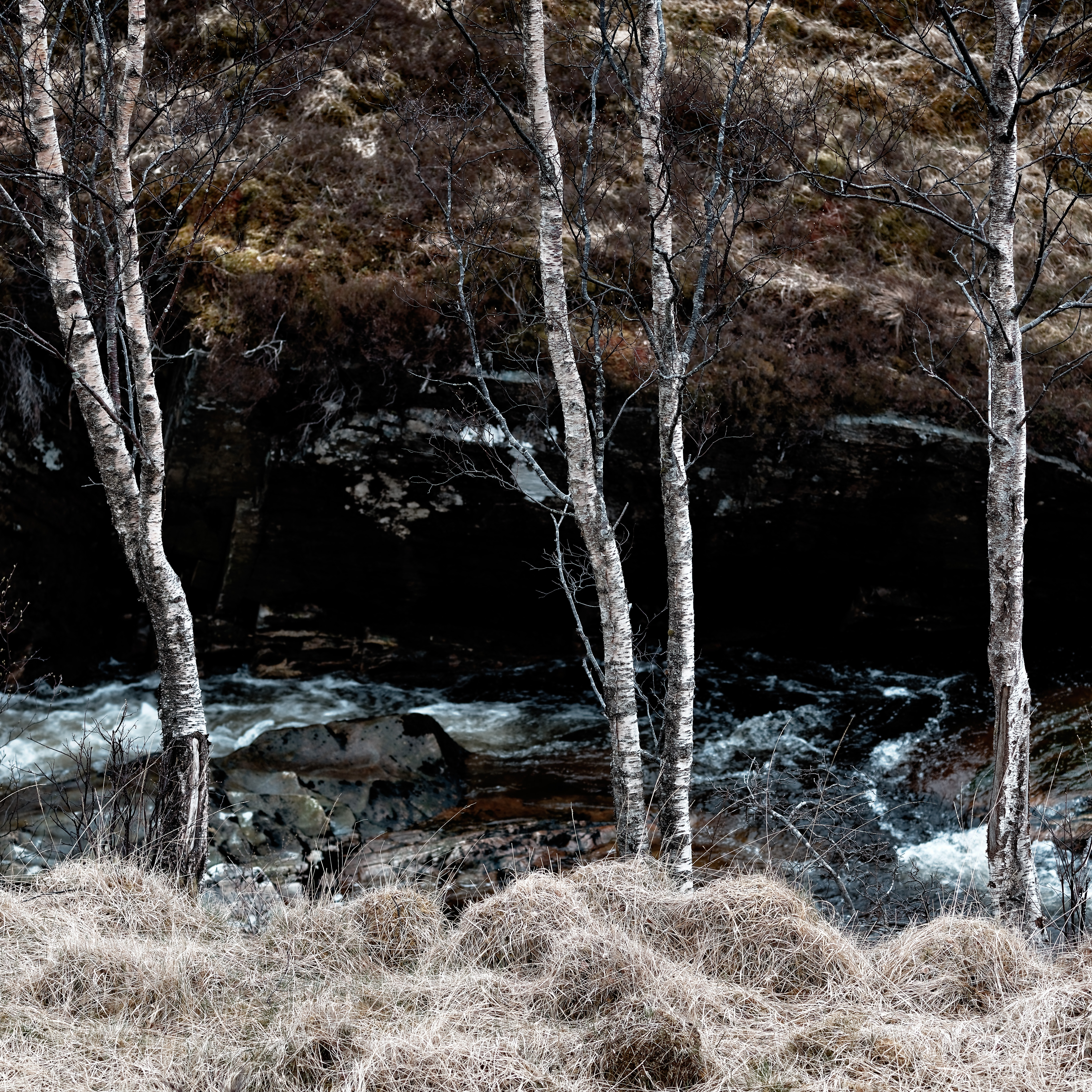
Glen Nevis trees

Glen Nevis trees

Not a unique idea …

This particular realisation was reinforced for me earlier this week when I received my copy of a stunningly beautiful photographic monograph, ‘Johsel Namkung, A Retrospective’ and read that he ‘walked for miles without a camera, looking for places to return to. Not searching for a picture, but for a place to return to where a picture might occur’. Perhaps a strong, emotional response to a place is best developed in isolation from capturing its reflected light? Maybe stronger images can result? And I would most happily have foregone the weight of all that glass and metal on the original walk! (Thanks to ‘On Landscape’ magazine for the review which prompted me to order the book.)

At the very least, compartmentalisation into walking and photographing allowed me to fully enjoy both the grim grandeur of a gloomy, Highland day and the subsequent, emotionally different time of using the landscape to make images. On this occasion it happened almost accidentally, but perhaps it’s worth adopting as a deliberate approach sometimes?

Musings on: using technology to pre-visualise images

I am now, or so I’m told by certain non-photographer friends, not only ‘fiddling with images’ in post-processing, but also ‘cheating’ by pre-visualising them with the aid of technology. Shocking! I refuted, or made a serious attempt to refute, the former charge in a previous post on the ethics of digital manipulation. I shall now refute the latter.

The charge goes something like the following:

“Using tools such as Google Earth and The Photographer’s Ephemeris (TPE) is cheating; you should just find places to photograph by wandering around.”

That is, of course, a paraphrase of what a non-photographer would say, but it’s what I’ve done for a couple of images, making it a reasonable one. In fact, I’ve been using TPE for well over a year now, it’s invaluable in working out where the Sun and Moon will be at a given point in time, at a specific location, and in determining both whether they will be visible and whether they’ll be lighting the landscape in the way that I would like them to. TPE, however, presupposes that I know where I’m going to be, whereas Google Earth, and in particular the relatively new ‘ground level view’ introduced in Google Earth 6, enables me to get a remarkably good idea of what things will look like when I’m standing at my chosen location. By combining the two it’s possible to go a long way to composing an image without even leaving the house. I don’t think that’s ‘cheating’, as such; I’d characterise it as taking advantage of technology to get a good result when it’s not practical to scout a location on foot and in a variety of lighting conditions

A real-world example using Google Earth ‘ground level view’

By way of example, I used both tools in creating the image below, which is of a valley in the centre of the Howgill Fells, in Cumbria, England, an area I’ve described in a post on its photographic potential. I’d noticed the interesting, interlocking spurs of hills on a previous walk in the area, but didn’t have a camera with me, and in any case the Sun was high in a clear, blue sky – less than ideal (and that’s why I didn’t have a camera…..). At the time, I just noted the location and then later, at home, investigated what could be done with it. It’s a non-trivial drive to the Howgills, followed by a walk-in of a few kilometres horizontally and about half a kilometre upwards, so I wasn’t keen on going up there at random and hoping it was worthwhile. To be honest, I probably would have done, but I felt much more confident that I was not about to waste my time, having planned it in some detail in advance.

The first thing I did was find the area in Google Earth, then I zoomed down to ground level, at which point the view shifts to the cunningly-named ‘ground level view’. This isn’t a tutorial on how to use the software, so suffice it to say that you can move around as if you’re walking and that the view you’d see is represented topographically. From my two ‘serious’ uses of this excellent facility, I can say that it’s sufficiently accurate to plan from – at least for the areas I’ve looked at. The following images are, on the left, a screen shot from the precise location I eventually stood to take the photo and, on the right, the image itself. The photo is zoomed a fair bit, so it’s of the top half of the Google Earth representation. No, they’re not identical, but they’re remarkably close if you look at the degree of overlap of the spurs and the shape of the river in the valley. Certainly, they’re close enough that relying on the software to aid visualisation saved me a good deal of hunting around on awkward terrain for a point to set up the tripod.

Google Earth pre-visualisation 'Hidden valley'

To show how close the representation is, I’ve deliberately done this backwards for the sake of this article, using the location data from the photograph to return to Google Earth and make the above screen shot. The on-line investigation I’d done in advance enabled me to mark a point which looked promising, and then drive / walk to it and be within fifty metres of where I ended up. More importantly, it let me play with compositions in advance. I was standing on what might be considered a steep slope which I had, of necessity, approached from above, and in inclement weather. Since I’d already determined, by ‘walking’ down the slope in Google Earth, the lowest level which improved the shot, I simply descended to that contour and then traversed the hillside until I found the composition I’d visualised on-screen as well as, more conventionally, in my head. Running up and down the hillside to see whether the composition would work better from lower down was something I was thoroughly happy to forego!

TPE

And what of TPE? Well, what I really wanted was sunlight on the right hand slopes, which means ‘sometime in the morning’ (the valley runs roughly north-south). More precisely, I wanted illumination, but not direct sunshine, so I’d used TPE to determine when the Sun would be low enough to not create harsh shadows anywhere – TPE showed me that this meant that I needed to be there within half an hour of sunrise. Unfortunately, the only place to park – the only sensible place to park anyway – is by an isolated house. Doing so at least an hour before dawn at any time of year might be considered anti-social; in late May, it really wasn’t an option. I settled for ‘any day with grey, high cloud’ instead. As it turned out the cloud was somewhat thicker than I wanted and it was decidedly dark in the valley, so the only thing which was still lacking precision was, as usual, the weather forecast! Oh, and it was raining and very windy too – a couple more things the weather forecast had assured me wouldn’t be the case…

TPE helped me work out what was best, I merely wasn’t able to follow its guidance on this occasion, though having now seen the way the various spurs in that valley lie, I’m sure the early option would be the best in terms of the end result – maybe I’ll return in winter.

'Hidden valley'

That, then, is the combination of techniques, but I’ve not yet actually refuted the argument that using them is in some way ‘wrong’; all I’ve done is say that this sort of planning is very practical and effective, at least for ‘big vista’ type compositions where the overall shape of the land is important – Google has not as yet recorded sufficient detail to enable anyone to decide in advance which trees to include in an image – give it time though.

Conclusion

Would I feel in some way better about the image if I’d not worked out roughly where to stand before I got there? I think not. I might have lost some time in searching around, up and down the slope which, as I’ve mentioned, is verging on being very steep. I might even not have found the spot, or left insufficient time to find it and found the valley even darker than it was when I arrived. If either of those things were true, then I’d possibly have felt some aching of the legs afterwards too. More probably, not being confident of how good the composition would be in advance, I’d not even have left home at six in the evening, aiming for a vaguely-defined point two hours travel away, so I’d not actually have made the capture at all.

Yes, perhaps the process is marginally less Romantic than wandering the fells hopefully in search of surprise compositions, but I’d emphasise the ‘marginal’ aspect quite strongly. It was raining, cold, and windy up there, and getting dark; had I not been near-certain of a good composition, I suspect that I would have turned back. This refutation is perhaps a largely pragmatic one, but I think it’s also convincing. I’m certainly not advocating doing this for every image; that simply wouldn’t be possible. Using the technique for certain types of composition, however, at least as a means of getting an idea of whether it might ‘work’ and where to start, seems to me to be a very helpful addition to the set of methods for pre-visualising compositions.

I’d be interested in hearing your views, especially if you disapprove of using such technological techniques for pre-composition, or pre-visualisation.

Addendum

Since I first published this article, Stephen Trainor, who wrote TPE, and Bruce Percy have jointly published an e-book in which Stephen describes all the facets of TPE and Bruce relates this to how he uses it in his work, in combination with Google Earth. i.e. exactly the same topic as this article, but with rather more ‘how to’ detail! I recommend it if you’re interested in taking this approach to planning images. ‘Understanding Light with The Photographer’s Ephemeris’