Locations for photography: Death Valley National Park, California
I’ve long wanted to go to Death Valley; now I want to go back sometime – very much so!
I thought I’d post a short piece to give my impressions of Death Valley and to say that it’s by far my favourite location of the many I visited in the area. It’s simply superb, if you like that sort of thing. i.e. deserts – which I do. There are plenty, or at least several, detailed articles on-line describing where to go and when, so this simply relates some personal experiences and tries to give an idea of scale and breadth of opportunity there.

It’s not only the photographic opportunities – though those are both multitudinous and, within the context of the emphatic ‘desert landscapes’ theme, very varied – it’s simply a highly accessible and stunningly beautiful piece of land. There’s a relevant proviso to the ‘highly accessible’ aspect, which I’ll cover shortly, but, generally speaking, everything in Death Valley is approachable by normal car and a short walk, or no walk at all in some cases. I had only two days there, yet managed to easily visit all but one of the primary locations on most lists of ‘things to see and photograph in Death Valley’. Yes, that did involve starting slightly before dawn twice, and finishing after dark, but at least, in late November, dawn was after 0700; almost civilised!
If you’ve read my piece on the Bolivian Altiplano, you’ll know that I’m rather keen on deserts in general, and varied, rocky deserts in particular, especially those with salt flats. Death Valley has all of those features, including actual sand dunes, albeit restricted to a rather bizarre, footprint-covered patch only a couple of miles across, the Mesquite Dunes, in the centre of the valley, plus some which are relatively hard to get to. The rest of the national park area is flat(-ish!) terrain with gravel, scrub and small rocks at one end and various forms of dried salt formation at the other – and it’s all surrounded by dramatic, multi-coloured mountains which rise to a high point 3,454m above the lowest place in the valley, Badwater Basin, itself 86m below sea level.
To add to those numbers, the valley also holds the record for the highest temperature ever recorded in the Western Hemisphere: 56.7C. That was in July; late November is much cooler, though still in the mid twenties during the day, and much hotter than that in the direct sunshine. My idea of thoroughly clement, in fact :-)

Lots of extremes and impressive numbers then; the main attraction to me, however, is the sheer grandeur of the place. No, it doesn’t feel especially like a wilderness – that’s tricky to pull off when there are well-maintained roads running the length of the park – but it does feel wild and it is a genuinely threatening landscape in the hot months.
From both the photographer and tourist perspectives, the main sites are no more than a couple of hours apart by road. That makes it a big national park, by desert SW standards (many, you could realistically walk around, but not this one), but perfectly compact for touring about and moving from one end to the other in a day to capture different places at what might be the best times.
For me, the main objectives were the Badwater Basin salt flats – essentially because they’re so thoroughly surreal – and Racetrack Playa, where the famous moving stones are located, the ones which have never been seen to move, yet leave long tracks on the hexagonal ‘saucers’ of mud in this very flat basin. Unfortunately, the easiest access to the playa is a 28 mile long, rough gravel road. This can be driven in a high clearance, two wheel drive vehicle, but given several pieces of advice that, even in an off-road 4×4, it’s a good idea to carry two spare wheels, I’m not entirely convinced of the good sense of that idea (well, I am: it’s a bad idea!). The good thing about that unfortunate omission from my trip is the compelling argument for going back ;-)

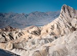
Even having missed out on the racetrack and the nearby dunes, the collection of places we did get to, including the famous Zabriskie Point, Ubehebe Crater (volcanic, not meteorite-induced), the Devil’s Golf Course, and several narrow side canyons with fascinating formations and excellent colours, was genuinely spectacular and, as I’ve said, enormously varied. Were I to find myself there for a couple of weeks, ideally with a 4×4, the opportunities for photography would be far from exhausted.
Naturally, doing anything which could be considered original in the valley is a challenge, and not one I even attempted in two days, but the iconic locations are iconic for good reason, so just being there and having the opportunity to admire and photograph them is enough!


4 Responses to “Locations for photography: Death Valley National Park, California”
Awesome place, I bet it glows at dawn and dusk. Nice .
It does indeed!
Great photos and inspiring words, Mike.
My wife and I visited Death Valley during a trip to the desert south-west in September 1995, I can still recall the feeling of awe at the sheer grandeur of the place; even by the standards of that amazing part of the world it is a stand-out location. I would absolutely love to go back now! Thanks for re-kindling some very happy memories. :-)
Doug.
Thanks very much! Glad to have rekindled those memories. It’s very much not the sort of place that can be forgotten is it.
And, rarely, it really is an awesome location. A much over-used word but entirely appropriate here!