mikegreenimages

Mike Green's thoughts on landscape photography

Archive for ‘February, 2012’

Locations for photography: the Lofoten Islands, Norway

Essence of Lofoten: Olstind + fish

To avoid any doubt introduced by the scant mention of negatives below…

I’m loath to be too gushing (just on general principle!) but Lofoten is unequivocally a fabulous place to visit in winter, both from a photographic and from a purely sight-seeing point of view. I’ve just returned from my first trip there and I think it highly likely that I’ll return one day, perhaps in summer, but more probably in winter again.

I feel I should start off by ‘confessing’ that, until about a year ago, I’d not knowingly heard of Lofoten! I’d travelled in Norway before, pretty much the length of it, but that was a long time ago and we drove around ‘seeing what happened’… What happened was that we missed one of the best bits – perhaps the best bit! Now, everyone I mention Lofoten to seems to have either heard of it or actually been there, so it’s rather less obscure than I’d imagined.

Lofoten

Where and what it is

For that tiny minority of people reading this who aren’t intimately acquainted with the location and topography of this string of islands: they’re towards the north of Norway, inside the Arctic Circle, and tenuously connected to the mainland by a series of bridges and undersea tunnels.

For context, I flew into Leknes, which is a little over an hour by road, or approximately 70Km, from the southern tip of the islands at Å (pronounced something like ‘awe’, and, appropriately, the last letter of the Norwegian alphabet). This area is essentially the southern half of the string of islands called, collectively, Lofoten. This isn’t intended as a place name list, and there are many sites which describe what’s where and how it’s strung together, so I’ll stop there! (For anyone feeling pedantic when reading this, the little archipelago of Røst is really the end, but there’s a lot of water between it and the ‘main’ Lofoten archipelago, so I’m choosing to see Å as ‘the end’ ;-) )

Lofoten
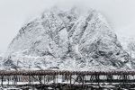
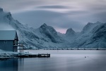
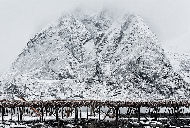
In appearance, the best analogy I’ve come up with for Lofoten is that of a somewhat broken up series of giant Toblerone bars, with the tops of the triangles protruding from the Norwegian Sea and their sides plummeting straight down into it. There is not an awful lot of flat land in Lofoten; just triangular mountains and water. I’ll concede that the Toblerone analogy suggests a regularity which is fortunately not evident, but it does nicely indicate the angle and overall, pointy ‘nothing here but mountains’ nature of the place!

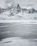
Mountains in most places rise gradually; these don’t. Many of them look as if a monolithic troll with a meat cleaver and a penchant for triangles has taken a perfectly normal mountain and fashioned something sharp and tooth-like from it with a couple of slanting blows. I’ve seen a great many mountains, and these are, especially collectively, radically different from most. Not that they’re very high – something in the region of 400-800m., but that does look big when seen from sea level and when they tend to be much closer to vertical than to horizontal!

Logistically and photographically

Conveniently, where the land does approach the horizontal – and there are some areas between the peaks where this happens – the inhabitants have laced the edges of the fjords with roads which lead to numerous sandy beaches and rocky shelves. And therein lies both a huge plus point to the islands and a slight downside, depending on your point of view.

So, from my perspective:

  1. On the positive side, getting around is easy; if slow on occasion. There’s a particular fjord on the main, E10 road, where a bridge has not yet been built across its mouth, making an 800 metre potential crossing into a 13 minute (yes, on about the fifth occasion, I timed it…) circuit of the fjord; but then, it’s a spectacular circuit! Even in winter, and in what I was told was an especially snowy time, all the roads, including the minor roads to dead ends at beaches, appeared to be regularly ploughed, and were certainly drivable with winter tyres.
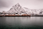
  2. The result of this excellent road network – and I emphasise that it may be ‘just me’ who sees a negative here – is that this is far, far from being a wilderness. I didn’t expect it to be, but I was surprised at just how copious the habitation and general signs of human activity are. This area is now, and has long been, extensively used for fishing, somewhat unsurprisingly – and it’s also beautiful. The natural consequences of these two things are lots of fishing infrastructure and at least a few, and often a collection, of houses on most accessible, flat areas. For example, looking at my image ‘Apostrophe’, from my previous post, you can just see, right in the centre of it, a small building…

That second point is a quibble, however; just something to be aware of when setting expectations for yourself before travelling there. Personally, I rather like just turning up in places and learning about them as I find them, rather than doing lots of research beyond the more or less essential ‘how to get there and how to get around’ sort. And the big benefit of the buildings is that, with very few exceptions, they’re pretty and can be used constructively in images.

Any hut in a storm

Consistently and photogenically colourful

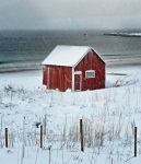
Each village / town / collection of houses decrees the one or more colours in which its buildings can be painted. We’re not just talking ‘red’ or ‘orange’ here – they prescribe a specific red and/or a specific orange, or whatever other colour(s) the settlement has chosen for itself. This means that each inhabited area has its own character imprinted by the single or multiple colours of its buildings. The result can be remarkably picturesque. I have no idea what the penalties for non-compliance are, but from the evidence I saw, people most certainly do comply. Reine, where I was based, has a mixture of a rather dramatic, strong red, a deep orange, and cream; in its winter garb of snow it looks thoroughly delightful and offers huge potential for dramatic, contextual, or simply pretty images.

On the importance of snow

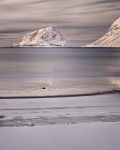
Snow is far from guaranteed in Lofoten, yet it is, I think, a very important aspect of visiting in winter. I’m not being facetious here: yes, it’s the Arctic, but snow is not omnipresent on the islands during the winter months since the Gulf Stream keeps things warmer than the inland, classically Arctic areas to the east. It’s rather similar to the way that the Black Cuillin of Skye are rarely in what mountaineers call ‘winter condition’.

As it was described to me, the snow can be around for a week or so, then disappear, only to be replaced a few days later. The day before I arrived, there was apparently no snow at all, whereas every day I was there brought fresh snow. In fact, it was more like every night, which was rather convenient for freshening things up :-)

Photographically, I believe the snow is very important, probably more so than in many places. The reason for that is the nature of the mountains. They’re very old, hard, dark rock; that’s how they survive this hostile environment and remain jagged and angular. With snow on them, the major features are picked out superbly as their steepness provides snow-free areas to contrast with the white. Many of my images show the mountains looking more like finely drawn pencil sketches than ‘normal’ mountains – an effect I very much like and one which absolutely depends on the crystalline covering.

Without the snow cover, my conviction is that the darkness of the rock would make dragging detail of shape and texture from the faces more than a little difficult. I’ve spoken to a few people about this, as well as looked at summer images, and it’s a conviction with some credibility I feel!

Lofoten

From bonsai landscapes to big vistas

The effect of this on my photography was that I was always drawn to the ‘big vista’ images showing these amazing, sketch-like mountains: I have relatively few detail shots. Yes, I did attempt some ‘fence in snow’ images and some ‘snow-covered tree’ images, but all that achieved was even more respect for people, like Michael Kenna, who can construct brilliant images from such stark simplicity! My feeling is that summer would be a better time – at least for me – to make ‘intimate landscape’ images. More than that, I suspect that the black, relatively featureless nature of the mountains would make this compositional choice almost inevitable.

Perhaps a week of primarily vistas is no bad thing, though after my very enjoyable focus on relative, sometimes scale-free, detail in the US deserts – my ‘bonsai landscapes’ trip! – I’m almost distressed at the number of shots I captured in Lofoten with both sky and several miles of landscape from corner to corner! That’s in part since I wasn’t inspired to photograph the buildings very much.

There’s a pre-visualisation lesson there I think: since I hadn’t pre-visualised images with buildings, I wasn’t drawn to them initially. In fact, as I said above, the colourful buildings against the snow, particularly the deep red ones, make very striking images indeed and those few I do have, I’m very pleased with.
Lofoten

OK – I confess to being very, very impressed with Lofoten…

In summary then, having intended not to write an entirely gushing article, and having read through it now, I acknowledge that I really was hugely enthused by Lofoten! Those minor issues I did have (human presence essentially – the lack of wilderness) can be seen as positive and as opportunities for different types of image; they can also be largely avoided by taking advantage of the surprisingly good infrastructure, visiting the more remote beaches, and examining what’s in the distance carefully!
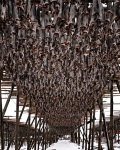
Finally: fish!

Oh! I should not omit mentioning what I’m told is a considerable additional, albeit non-photography, benefit of visiting in winter.
Lofoten

  1. The main industry is fishing, with the second, I presume, being tourism, and that largely in summer.
  2. The fish are exported dried, having been hung on large racks for non-trivial amounts of time to dessicate.
  3. These racks are ubiquitous in the settlements.
  4. If you like the smell of fish, that would be a good thing…. personally, I don’t.

Fortunately, in winter, despite there being tens of thousands of drying fish everywhere – probably hundreds of thousands; a lot, anyway! – the aroma is only apparent close up, as a result of the cold. I imagine this is not true in summer: the fish bodies are taken down in June, but the heads take longer to dry; so winter gets yet another positive tick from me ;-)

By the way, the gallery images below seem to be much better than the embedded versions – I allowed WordPress to size and resample these. And if anyone has any detailed questions about where things are, etc. please do feel free to ask – I’m more than happy to help whilst I can still remember!

Lofoten


Locations for photography: Lofoten (preface)

I’ve recently returned from a week in the Lofoten islands in the north of Norway; the Arctic in fact. I shall write an article in the not too distant future about my impressions of the place; this is just a quick post now that I’ve finished processing my captures.

'Apostrophe'

I was on Bruce Percy’s first ‘photo safari’ to Lofoten, named as such since it wasn’t a traditional workshop, more an opportunity to spend time photographing with Bruce, who’s great company and has now visited the islands several times, so has excellent local knowledge.

All I want to say at this stage is that, as I’m sure many people reading this will already know, either through having been there or from reading about it, Lofoten is a fabulous place. Irrespective of whether the primary objective is to photograph it, just being there was a wonderful experience. This was helped by the fact that we were fortunate in having near-perfect weather, with storm fronts rolling in daily and bringing fresh snow, but nothing too severe fortunately (that came a day after I left and it closed the roads and airports…).

Just a couple of points on logistics…

Lofoten in winter is off-putting to a lot of people. Fair enough: it’s not unreasonable to imagine that the southern fringes of the Arctic are potentially somewhat inhospitable in mid-February. My concerns on that front were ill-founded, however. Yes, it was cold, but temperatures were only a little below zero in general and, whilst the wind-chill did make this subjectively cooler, that’s something you can compensate for by making sure all your clothes are wind-proof. I did, and I was fine and perfectly able to capture photographs every day. Critically, Lofoten, like north-west Scotland, benefits from the gulf stream (though there is a notable absence of the palm trees found in places like Poolewe!), so it was 20C warmer than a couple of hundred miles inland, in Sweden, at the same time!

Another thing is access. There is a risk of the occasional flight not making it out; usually due to said flight not making it in: the planes can’t land unless the pilot can see the runway, and snow flurries tend to have an obscuring effect! The infrastructure in place for clearing roads and runways is superb, however, and, whilst there was a lot of snow each day, we never had a problem getting to even the more remote beaches. Of course, Bruce was driving, so transport was arguably not my immediate problem, but with studded winter tyres and ploughed roads, all went very nicely. Yes, there is the possibility of a delay arriving or leaving, but usually a later attempt will be successful, and the pilots are very used to the weather conditions there.

So, yes, do go in winter if you like stark drama! My impression is that the place would be utterly different in summer since the black rock of the omnipresent mountains was superbly picked out by the snow cover. Obviously, that’s absent in summer and the textures and shapes of the mountains could be more difficult to work with.

The final thing I’d like to say in this first, short post, is that our accommodation at Det gamle Hotellet Guesthouse in Reine was excellent; perfect for our needs. I can unequivocally recommend Lilian’s guest house as a good base if you’re thinking of visiting Lofoten.

Once I’ve worked out what my thoughts on Lofoten as a photographic location are, I’ll write more. For the moment suffice it to say very positive!

'Apostrophe'

Oh – one last thing: we did see a spectacular display of the Aurora Borealis on 14th February, but we were surrounded by houses at the time so my images are… ‘colourful but uninspiring’ is probably fair. I was debating whether to publish any when I saw Joe Rainbow’s most recent northern lights image on Flickr, ‘Green tsunami’, which is excellent and convinced me not to! http://www.flickr.com/photos/24562498@N03/

Locations for photography: Canyon de Chelly, Arizona

My final ‘locations for…’ item from the US

Were I to write about all of the remainder of the locations we visited in the US recently, and which I’ve not yet talked about in the last few articles, I’d be covering old ground, both in the sense that they are very well-described on the web already, and in that I’d be repeating some general observations which I’ve already written. Monument Valley, The Grand Canyon, Bryce Canyon, they’re all much-photographed and very familiar subjects to many people. They are all, of course, well worth visiting simply to experience the grandeur and sheer scale of each of them.

Canyon de Chelly is another matter. Maybe it’s just me, but it feels considerably less well-known than everywhere else on our drive. It was recommended to me by a number of US friends, however, so perhaps it’s more prominent as a destination if you live there?
Canyon de Chelly track
For those who’ve not heard of it, it’s a y-shaped canyon near Chinle, not far from the New Mexico state line and deep in the Navajo Nation area of Arizona. It starts off, at the point where you access it by vehicle, level with the surrounding land and rises to something in the order of 300m. at the far end of each of the two upper parts of the ‘Y’. It contains a river, through and along which you drive (are driven, in most cases) when taking a tour. Along its rim are numerous overlooks from which it’s possible to look down, and from one of which a descent to the canyon floor is both easily possible and permitted. Apart from that, access is only allowed with a Navajo guide.

The dominant features of the canyon are red sandstone, cottonwood trees, the meandering river, and numerous ancient, native American dwellings built into the cliff walls at various heights. These indicate how high the canyon floor was when they were built and date back nearly a millennium in some cases. It is, I can comfortably say, a marvellous place to visit.

Our Navajo guide was excellent, being very knowledgeable about the history of the place, as well as tolerant of frequent stops for photography and just wandering about. He waited ages, for example, whilst I attempted to find an angle which would allow me to exclude the green fence which marred the lower-right corner of the image below. I failed at the time but removed it later after some kind advice on Flickr. His tolerance may have been helped by it being off-season, though I think he was just very helpful. We also weren’t hanging about too much since a major storm system had skirted the area the day before and was still putting down snow throughout our time in the canyon (as can be seen in the images in this article, especially when viewed in the larger sizes).
Golden Fleece

But is it good for photography?

I think so! As with all canyons, capturing the scale is tricky, and the nature of access, by 4×4, through a river, and with a guide, means that repeated trips might be necessary to really work out what to do with the subject matter (this would become expensive!). Nonetheless, there are some very interesting colours in the trees and the canyon walls, and some spectacular views from the canyon rim.

We had just a half day in the place, which was sufficient, given the rather low ambient temperature and constant snowfall, but I saw a great many interesting rock formations, groups of trees which simply must have compositions within them, and areas of the river where reflections and winding sub-streams would make interesting abstracts.

Considering the wider area beyond the canyon itself, this is very much deep in Navajo country, and there were very few people indeed who were not native Americans – neither in the motel we stayed at, nor in the surrounding area. It was a fascinating cultural experience as a result. I was particularly amused by being informed at a fuel station, by a boy who looked about 3-4 years old, that “You’re not Navajo”, in a tone which suggested that this observation was worth making, at least to him!

I have no idea how busy the canyon becomes in peak times of the year, but visiting it in December, when we were the only vehicle there, was an excellent experience.

To return to the wider trip. I’m not going to write anything more as I have nothing photographic or observational to say about the other locations, other than that they’re as good as they’re reputed to be! I shall, however, finish with the following images from a sunrise and a sunset at Bryce Canyon, purely since the sheer vibrancy of the colour on the hoodoos was astonishing, even though I’d seen countless images of them before. These shots have both been desaturated considerably.
Bryce Canyon hoodoosBryce Canyon hoodoos

Tripod substitutes

Both images are also examples of captures made with the assistance of the Mandypod, an excellent tripod substitute which I promised to mention in one of these articles.

Whilst only a bipod (biped, technically), and only five feet high, this device is very flexible and makes a fairly good camera support when a tripod is not available. It did tend to vibrate, or shiver, slightly when the temperatures (as for the sunrise image) dropped to minus 19C, but it was, nonetheless, considerably better than hand-holding the camera, since I was shivering rather a lot at the time too… Not only that, but it’s self-powered, does not require carrying, and occasionally responds to voice commands. Height adjustment is naturally limited to six positions: the camera is located on top of the head or shoulder and this is combined with instructing the ‘pod to sit cross-legged, kneel, or stand upright. These six levels were invariably adequate, however. Extra stability can be achieved by locking the camera-holding arm around the neck of the ‘pod and bearing down firmly, although this could lead to stability issues if maintained during an exposure of more than a few seconds (due to a process known as asphyxiation). I was very grateful indeed to have the use of this device on a number of occasions when strong winds would otherwise have made shots impossible :-)


Thumbnail links to gallery for this article

Locations for photography: Zion National Park, Utah

Cottonwood congregation

I spent four nights in Zion and made not a single ‘big landscape’ image

Perhaps that sounds odd, in that Zion is a vast canyon with soaring, near-vertical rock walls and a generous helping of overall magnificence. It was our last stop on the long trip around the desert south-west of the US though, and by that time I was reacting against big pictures and literally focusing on detail everywhere. Fortunately, Zion has an abundance of excellent detail!

As with the other locations we visited, Zion has already been heavily documented and photographed, so this is a short piece about my overall impressions of, and reaction to, the place.

Zion cleftIn summary, and to be slightly contentious: it’s a US version of the English Lake District. I realise that anyone who’s been to both places will recognise that, in isolation, that’s a radically misleading statement. What I mean is that it feels like the Lake District; it’s atmosphere is strangely similar. It’s not the landscape itself that has this feel; it’s the way the landscape is used by people.

  1. It’s on a small scale – in fact, the principal canyon is not a great deal larger than Langdale, in terms of area, though it’s a winding, 10Km long, 500-700m. deep canyon cut into the surrounding desert.
  2. It feels very tame, compared to other national parks in the US south-west. Feels is the important word there: the Lakes don’t have cougars, rattlesnakes or bears, but then again, for most practical purposes, nor does Zion. The main areas are so populous with humans that the potentially aggressive wildlife stays well away. Conversely, the deer living on the canyon floor are so used to humans that they’re verging on tame and can be approached to within a couple of metres!
  3. Zion zig zagsIt’s manicured – not quite literally, though it is very neat. The owners of Zion Lodge (the only place to stay actually in the park) are currently converting most of the lawns around the buildings back to natural vegetation, yet the nature of the terrain means that the paths (sorry, trails in US-speak) are often the only option. Straying from them is sometimes forbidden, often impractical, and most are paved for the mile or so from the parking area which the average visitor will manage.
  4. StreamEven in the off-season, and mid-December is about as ‘off’ as it gets, we saw more people in Zion than anywhere else on our circuit. That’s not to say that it was anything approaching crowded, it was perfectly comfortable, but it certainly was relatively busy. I dread to think what summer is like, when the road up the canyon is closed to private vehicles and access is via what is apparently an excellent, multi-stop shuttle-bus service.

All those characteristics just kept making me think of Lakeland…. but a restricted Lakeland, one with:

  • less variety in its colours (a completely different palette in fact, but a more restricted one, at least in December);
  • Still deathless potential for choosing your own route from A to B;
  • and less space, both in real terms and in the naturally imposing nature of very high rock faces and a flat, narrow canyon floor littered with very neat, very well-maintained stopping places and viewpoints.

But hey, I like the Lake District – subject to the normal caveats of going there when it’s less crowded than it can often be – and I liked Zion. In particular, it was a great place to relax for a few days at the end of a long trip and many miles of driving.

Photographically, I found it excellent for the type of image I was, by then, making

It’s true that the rock which makes up most vertical and horizontal surfaces does tend to be the same red/yellow sandstone throughout the park, but it consists of numerous layers, and those layers vary in their thickness, degree of erosion, and pattern. If you want to look for abstraction in rock, this is a fabulous place to visit. One rather pleasing feature is that semi-abstract compositions can be made wherein the scale is very hard to determine: some of the rock images above are tens of metres across, though they could appear to be an order of magnitude or two smaller, at a glance (they often do to me, and I took them!). For example, if you examine the top right of the zig-zag rock image above, at the large size, there’s a bush there. That bush is about the size of a medium-sized dog, whereas I keep thinking the whole image is a small area!

Frozen in amberIn early winter, there are also frequent pockets of ice to be found, held in the curves of small watercourses, often with decaying vegetation, both encased in the ice and lying on the surface. I used these to add some different colours to what was otherwise becoming something of a ‘red and granular’ series of images.

Zion ice creamWould I go there again? Yes, though I wouldn’t wish to go out of my way too much to do so, and if I did it certainly wouldn’t be in summer. Further, I’d be looking to concentrate on similar subjects to those I found this first time. A search on images of Zion will bring up many shots of the sheer grandiosity of the canyon itself, but examine those carefully and there are relatively few significantly different compositions – the nature of the place is that it has a number of viewpoints,and the sheer scale of the rock walls means that varying a composition from the norm is decidedly tricky. Moving away from those viewpoints very much, certainly in a direction which would enhance the composition, tends to require the power of flight!

I do strongly recommend a visit there if you have the opportunity, I’m certainly very pleased indeed to have gone; but set your expectations appropriately in terms of the type of photography it’s possible to practise, and enjoy it also for simply being a rather wonderful place with great drama, easy access and, if you’re vaguely fit and can follow steep, but well-trodden trails up to 700m. from the valley floor and back down again, some superb viewpoints.
Winter colour

All of the above is, of course, very generalised

It’s entirely possible to go to Zion and make some superb ‘big landscape’ images, as proven by the number of great photographs that exist showing it looking truly majestic. My approach was somewhat dictated by the equipment I had with me, but, as I said above, it had more to do with simply having had a near-surfeit of ‘big landscapes’ by the time I arrived there. That said, in this particular case, I do think that the wealth of small scale, detail / abstraction / texture / colour images are the most interesting subjects Zion has to offer…
Zion waves


Thumbnail links to gallery for this article